Agassiz Provincial Forest
Public Group
Active 4 months, 1 week ago
Group Leadership
- Group Administrators
-
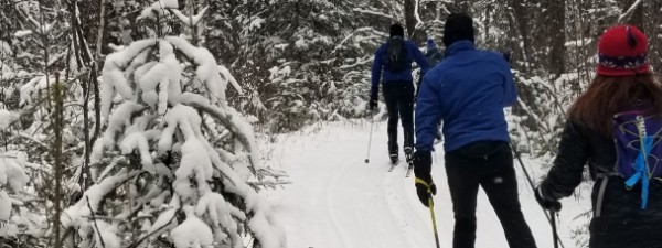
The Lac du Bonnet Cross Country Ski Club maintains classic ski trails in the Agassiz Provincial Forest. The trails have gentle inclines and wind through rolling gravel ridges, mature and plantation forest, and surrounded by spruce bogs and the occasional poplar bluff.
The Blue and Red trails were logged in fall 2020. Trail groomer Carl Nilsson has been able to groom them again starting in 2024.
A new (2020) Yellow trail connects from the Green trail on the west side of Pit Road and goes south. A new (2024) trails map is at the Maps tab, below.
So there is now 16K of trail.
The trailhead is located on the south side of PTH 317, 15 km west of Lac du Bonnet or 34 km east of the junction of PTH 59 & PTH 317 (or 80 km NE of the Perimeter Hwy & PTH 59). There is no signage on PTH 317, but the parking lot can be seen from the highway. There is a trail map at the PTH 317 trailhead, and all trails have excellent signage.
There is a porta-potty at the PTH 317 trailhead, and another on the Blue trail near an old open shelter.
Please support the maintenance and grooming of these trails by sending a donation / trail fee to:
Lac du Bonnet Cross Country Ski Club
Box 1198
Lac du Bonnet, Manitoba
R0E 1A0
or by Interac e-transfer to mzienkie@live.com
The club president is Karen Nilsson, nilssoncarlb@gmail.com .
Maps List
-
 Agassiz Provincial Forest ski trails map [2024] (5.3m)
 2024-01-19 The Yellow trail has been changed to hopefully avoid quad and snowmobile damage, and the logged Blue and Red trails are now back!
